Tuesday, May 27, 2008

Farah

We travelled out to the western Province of Farah and visited the City of Farah in Mid-February. While it was about 25 degrees in Kabul, it was about 75-80 in Farah. The province sits on the border with Iran and is a fairly strategic region. The people obviously have more of a Persian influence, yet most are Sunni opposed to the dominant Shia in Iran. Flying into Farah was quite the adventure. The C-130 had to make a stop in Kandahar first and we ran out of day light. The Farah airstrip has no landing lights, so the crew got out their night vision and drove on.

Some local kids looking for candy or water. The contraption to the right, is the communal well.


Another street scene in the city. Notice the domed roofs of the houses. This helps keep their homes relatively cool in the 120 degree summers.


This is looing across the airstrip. The dots in the background are burned out and destroyed Soviet APCs (Armored personnel carriers).


Here I am with some NDS (National Directorate of Security, dudes in green) and the 1st Deputy Minister of the Interiors PSD (guys in blue).
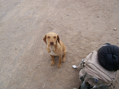
This little guy belonged to one of the Afghan airport workers. He would break my heart a month later when I re-visited Farah. I saw him barely walking and obviously not eating.

Sunday, May 25, 2008

Mazar-e-Shareef

Mazar-e-Shareef or MES is in northern Afghanistan. Generally, the folks who live around MES are Uzbek or Tajik. Contrary to what many believe, Afghans are NOT Arabs. Many are of a Turkic and/or Arayan stock. It is not unusual to see Afghans that look like people back from home. And true to the fact that Afghanistan was the cross road of the Ancient silk route, there are many different cultures represented here. There are ancient Greek settlements, people of a more Persian influence and of course there are the Pashtuns. The Pashtuns are the majority ethnic group here in Afghanistan and they generally occupy the territory south of the Hindu Kush Mountain range. Another minority, is the Hazaras, who live in the Hindu Kush Mountains. The famous standing Buddhas of Bamian is their heartland. In Persian, "Hazara" means one thousand and the term Hazara was also utilized as the name for a regimental sized unit in the Mongol army. Indeed, the Hazara are the direct descendants of the Great Khan and they were named after the regimental sized occupation troops Khan left behind.


The dominant religion is of course Islam, with most being of the Sunni faith. The Hazaras and small smaller groups are Shiite. While Islam is a guiding beacon for every aspect of life, Afghan Islam has been adapted to the unique challenges and needs of everyday life in Afghanistan. To a certain extent, there is a blending of faith and survival. The most prominent example would be the blending of the Pashtunwali Code of ethics and Islam. The code is the way of life for the Pashtun culture, but make no mistake, Islam is the guiding light.


Taken from the airfield in MES, these two unimpressive pictures mark a fairly important geological barrier in Afghanistan. Above is a shot looking south, at the northern slopes of the Hindu Kush mountain range. The below photo is looking north, towards the steppes of central Asia. In my time here in Afghanistan, this is the only time I have seen flat terrain.


Friday, May 23, 2008

NCO Graduation and Kabul


In Mid-Feb 08 I travelled over to the ANP NCO Academy in Kabul in order to attend the NCO graduation


These are some Afghan National Civil Order Police (ANCOP) being inspected at the Ministry of the Interior.

New NCOs in formation
Minister of the Interior Zarar greeting ANP generals.
Street scene in Kabul. Notice two females in Burkas under the billboard featuring women not wearing Burkas. Look at the top floor of the building under construction. Pretty scary but common building technique. Kabul is surrounded by hills and mountains which does not stop the Afghans from utilizing every inch for their dwellings. The folks that live on top of the hill, have to walk down to the bottom in order to retrieve water from a neighboorhood well.
Another shot of some Afghan shops along the road.

Flight to Jalalabad FEB 08

Kabul is over one above sea level. So flying just about anywhere from Kabul means you go down in elevation and up in temperature. In Feb 08, I flew on UH-60 Blackhawks to Jalalabad which is where the traditional Afghan royal winter quarters is located. Indeed, it was about 25 degrees in Kabul and about 65 degrees in J-Bad


This picture was taken over KMTC which is the Afghan armies (ANA) training area. If you look in the middle of the picture, you can see a line of men who are no doubt ANA soldiers at the firing range. You can also click on the picture for a closer look.
This is the Kabul River flowing through the mountains towards J-Bad. The helicopter followed the river gorge through the mountains which are about 15,000-18,000 feet high.

Click on the photo and you will see the Afghan village built into the side of the mountain. Notice the terraces for growing their food. Also notice the lack of snow as we flew to lower elevations.

The two photos above are the city of Jalalabad, which is located in a green zone. Green zones are areas located next to water and stand in contrast to the arid surroundings in most of the country.

Wednesday, May 21, 2008

Camp Eggers and Ghazni Jan 08

I have been assigned to the Combined Security Transition Command-Afghanistan (CSTC-A)

I work for the Deputy to the Commanding General for Police Development. In other words, we are tasked with facilitating, supporting and resourcing Afghan National Police training and operations. I am stationed at Camp Eggers in Kabul. The above picture was taken on the main street looking west at the mountains.


My first trip was to the ancient walled city of Ghazni, in Ghazni Province. The city is rumored to have been mentioned by the Greek historians from the beginning of recorded time.

This picture is the citadel located on the high ground of the walled city. You can see the blue dome of the mosque in the lower right corner. In the upper right corner is a gap in the wall, this is the Kabul Gate which was blown up by the British in 1839.

These are villages composed of compounds or qalats. The individual gardens and orchards are surrounded by walls and irrigation channels.

If you look to the left, there is a series of holes called Karez. Karez is the ancient underground irrigation system The holes follow underground aquifers and provide water to the villages. The Afghans have been known to hide in the Karez so that they can ambush invading armies. Genghis Khan and the Soviets, 1000 years later were faced with this tactic and both systematically destroyed much of the Karez. In order to get to Ghazni from Kabul, we had to fly through mountain passes with the peaks towering above our heads.

Catch Up!

Well folks here I am, back in the saddle. I have some catching up to do. So I will start from the beginning. January 2008, Camp Phoenix and the trip over.


Papi and I in Ireland.


Here is Papi with a real live Irish guy. As always, Papi gets into the spirit of things.


This monstrosity is a up armored bus, the Pope Mobile has nothing on this thing.


2nd Platoon crammed into a C-130 moving out down range.


These are some of the kids who work the local Bazaar. They drive a hard bargain.

Thursday, January 10, 2008

AFGHANISTAN

Well folks my sincere apologies for not updating recently. As you probably know, we have been quite busy. The Roughnecks left Ft. Bragg on 21 December at zero dark thirty. No photos were allowed on the flight line because certain aircraft mistake camera flash as missile flash and then shoot out their flares. No kidding... Our first stop was Shannon, Ireland where Papi met real Irishmen! We then flew to Adana, Turkey where we re-fueled, but were not allowed to get off the plane. Finally after 20 hours in the air, we landed in Manas, Kyrgyzstan on an old Soviet airfield. Manas is located north of the Kyrgz Capital of Bishkek. After a few days, some of us flew to Bagram and others to Kabul on very crowded C-17s.


We flew over some of the most desolate terrain the planet has to offer. I took this photo from the C-17 standing on my gear, the window is about the size of my out stretched hand.


We landed in Kabul the day before x-Mas. We were picked up by up-armored buses (I will post picture later) and escorted to Camp Phoenix by the Germans and Americans. Kabul is surrounded on three sides by mountains, it is pretty hazy and dusty all of the time. But there are a lot of cars and shops which is a good sign.


There is a lot of Soviet equipment laying around some of which is still in use. This is a Russian HIP cargo helicopter in flight over Kabul.

The majority of the troops did not stay in Camp Phoenix, they moved out all over the country. We have soldiers stationed in almost every single province in Afghanistan. Here are the Boys from 5th Platoon the "Fighting 69th" taking off for Gardez on CH-47s.


That is all for now, I will update again real soon. If you have not heard from one of the guys yet do not worry. Some are still in transit, they will get a hold of you. For now-signing off.