Friday, June 6, 2008

Konduz and Char Darreh May 08

We flew north on new C-130 J model with about 150 hours flight time on the air frame. In order to get to Konduz from Kabul, we flew over over the Hindu Kush Mountain range. Deep in the valleys are isolated villages that have no road or electricity. Whichs bears me to ask the question, do they care about what is happening in the rest of the country? We landed in Konduz and were welcomed by the local ANP contingent. The Konduz airport is managed by the Germans and is located next to their PRT.


Deputy Minister Mangal reviews the police officers on the airport tarmac.

A few derelict Soviet MI-17s in the background.


A donkey cart, which is the main form of transportation in this section of the country.


Crossing over the Konduz River on a real shaky bridge. We crossed the bridge one vehicle at a time.


Farm land.

The Char Darreh District ANP Headquaters

A UXO (unexploded ordnance) I almost stepped on like a dumb ass. And yes that is my footprint next to the thing.

The ANP HQ arms room located in a old locked connex.

The ANP HQ kitchen. The guy is cooking rice.

This clown wanted to try out my body armor.

Camp Morehead 2 May 08

Went south of Kabul to Camp Morehead in order to re-zero my weapon and my ACOG (4x sight). I did some CQM (Close quaters marksmenship) and just shot a crap load of rounds. I even shot my "nine".


This is the village located next to Camp Morehead
The firing range at Camp Morehead with a burned out BTR-60 Soviet APC. Not only did we shoot a bunch of freakin ammo, we also blew up some demo.

This is just a shot of the close quarters we encounter on the roads of Afghanistan.

Darulaman Palace or the King's Palace was built in the 1920s by King Amanullah Shah. The palace is now in ruins, but there is talk of restoration. The Queen's palace is located on some high ground to the left, (not pictured).

The gap in the background was known as the Lion's Gate. The high ground on the right is where the famous Kabul wall is located. The Kabul River is just to the left of the wall on the left side of the road. The "Old City" is located through the gap opposite the Kabul wall.

The ruins of the Kabul wall in the Lion's Gate.

Small fort locted at the terminus of the Kabul wall in the Lion's Gate.

Saturday, May 31, 2008

Adraskan

In early April I travelled to Adraskan District in Herat Province which is in north western Afghanistan. The purpose of the trip was to attend the opening of the new Afghan Civil Order Police (ANCOP) training facility.


The dark circles in the background are the tents of the Kuchi, which in Persian means "those who travel". The Kuchi are bedouins or nomads, and their tent villages are scattered all over Afghanistan. They always settle near a water source and all of them have large herds of goats. They live just like Abraham did in the Old Testament.


The terrain in north west Afghanistan is hilly but not as mountainous as the east. The environment is dry and arid with scattered green zones near rivers and water sources. The specks in the background are a Kuchi goat herd.

This is one of the green zones fed by irrigation ditches by the river in the far background.

A close up of one of the goat herds

Another Kuchi settlement with a cemetery in the foreground

Irrigation fed fields with a goat herd on the slope in the background.

A permanent village, and much like Farah, the dwellings have a domed roof.

Even though many Afghans have vehicles, most still rely on beasts of burden. It is not unusual to share the highway with donkey carts and cars.

A hasty formation of the 1st ANCOP class at their new facility.

A fish out of water. An Italian HH-3F Sea King Helicopter. This bird brought in the General and the Minister of the Interior to visit the facility.


The Italian version of the Apache flying escort for the Sea King


ANP LTV (Light Terrain Vehicle), the work horse of the ANP.


J-Bad April 08

On my birthday in April, I flew down to J-Bad to inspect a Afghan Border Police (ABP) training site. We rode on a State Department, Soviet built Mi-8. The State Dept. does not use Americans as pilots and generally hires out all security functions to Gurhkas.

Here are the ABP recruits taking in some class instruction.

This is a picture of a "green zone". The green zone obviously gets its name from being green in contrast to the overall brown arid surroundings. Green zones are located near rivers and wells. Since there is no concealment in the desert, the enemy will hide in the green zones, especially larger ones.
When we arrived back in Kabul, the helicopter landed just before a dust storm struck the city.


This picture is a Soviet version of the C-141 , except the engines are much smaller on the Soviet aircraft. This particular bird, flown by contractors obviously had an engine fire and the guys crawling over the plane are stripping its parts. I spotted this damaged aircraft on a quick trip to Kandahar.


Friday, May 30, 2008

Farah II

Due to a deteriorating situation in Farah, I travelled out west again in mid-March. This time with the 1st Deputy Minister of the Interior.


Much of Afghanistan is littered with battered Soviet armor. This is a BTR-60 Armored Personnel Carrier lying off the side of the road.


This is a Afghan cemetery.


The Farah Bazaar


Another street scene in Farah City.


Among the many groups we met with, this one was the most interesting. The Farah Provinicial Jihadi Council. No kidding.


This guy is one of the ANP servants for the Farah Governor. I asked if I could take his picture and he straightened up and posed for me.


This is what we call the Gloryhole. Everyone squats when they do their business here.


This is one of the gardens in the Governor's compound. All gardens in Afghanistan are planted in depressions because of the arid environment. The water pools in the depression and soaks the plants roots.

These two guys were my travel companions. I call the guy on the right, "Haji Eddy" the ceremonial head of the Jihadi Council.

At the Farah Provinicial Police HQ are these stacked Soviet APCs. The one on top is a BTR-60 and the one on the bottom is a BRDM.


The following group of photos were taken at the citadel in Farah. The citadel has walls that are about 50' high and 50' thick. It is over a kilometer across on the inside. Up to about 90 years ago, the entire city of Farah was located inside the walls. The citadel was built by Alexander the Great's occupation troops over 2000 years ago.

Interior walls.

Me inside the citadel. You can see the far side walls in the background.

This is the one of two gates entering the city. This is the west gate which is the smaller of the two. This was taken from the inside of the citadel.


The ceiling of the west gate.


The exterior of the west gate.

This is a shot of the exterior walls of the citadel


The main gate or east gate of the citadel. The vehicles in the foreground are more derelict Soviet vehicles. The Soviets utilized the citadel as a base during their occupation of the region.


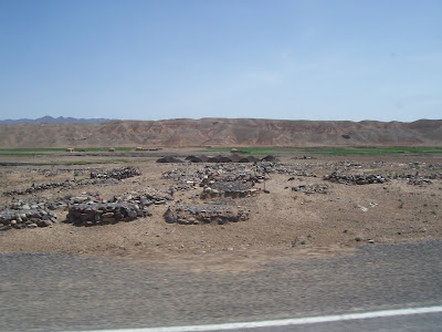
All of the mounds in the foreground are the ruins of ancient homes within the walls. In the background is the Bala Hissar which to this day serves as a base for an ANA Kandak (Afghan Army Battalion).

This structure on the north east section of the citadel was built much more recently. It now houses a ANP checkpoint.